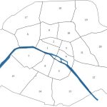
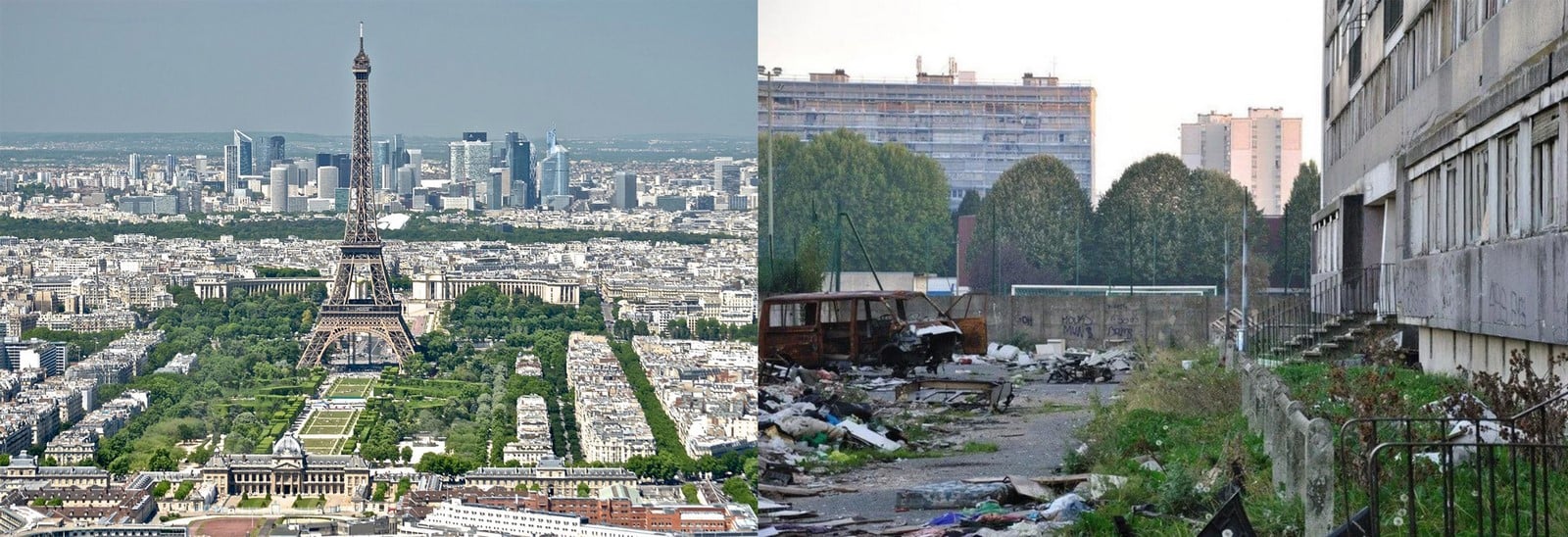
Paris is inevitably known to be one of the top international cities in the world. While it is the wealthiest city in France that offers ample opportunities and quality of life to the people, it is also the highest generator of social and economic issues in its country. One can witness extreme social differences in Paris, as it consists of both the urban rich and the urban poor. The city is divided into 20 arrondissements (or sectors), and the following statement holds good that the true representation of what the city of Paris portrays to the world is limited only to its eastern arrondissements.

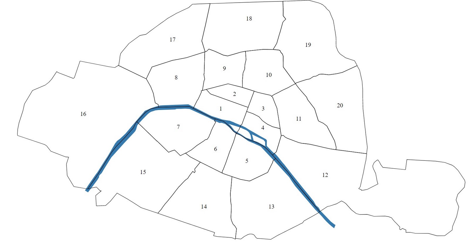
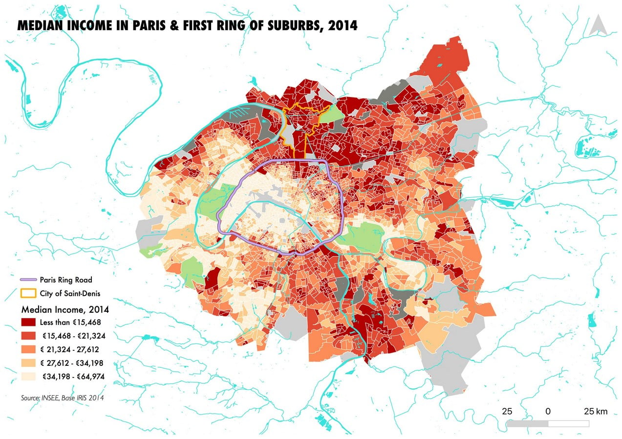
There is a clear distinction between the eastern and western arrondissements of the city, segregated by the wealth of people. For instance, the eastern side belongs to the urban poor and the western part is owned by the affluent. This social divide became prominent with the start of industrialization in the 19th century, when the native and working-class immigrant population arrived and settled in the outskirts of the city as many of the factories were being established there. A recent study revealed that the eastern side of the city was usually more polluted due to the westerly winds blowing off the emissions from the industries towards the eastern direction, which gave reasons to the wealthier people to abandon the east, freeing it for the poor. This article brings forward some of the marginalized and deprived areas in Paris and highlights the reasons behind their stigmatization responsible for widening the inequalities of the city.
The Land of Immigrants: The 17th, 18th and 19th arrondissements of Paris | City of Paris
The western parts of Paris, particularly the ones closer to the Paris Ring road (peripherique), are regarded as the districts with a high concentration of social and economic issues in the city. The 17th arrondissement of Paris acts as a divider between the east and west, consisting of strong urban segregation within itself among the urban rich and the poor. On the other hand, the 18th and 19th arrondissements are home to the city’s poorest people. It is classified as one of the poorest arrondissements in Paris, with a history of immigrants and an abundant presence of drug dealers and addicts. It was traditionally a point of entry to the capital for the migrant working-class population during the industrial era of the 18th & 19th centuries, welcoming people from Eastern Europe, Africa, Maghreb and some south Asian countries, forming small communities within the neighbourhood.
With the end of this era, a large number of people lost their livelihoods; some were tagged as unemployed, and others relied on underground activities for income, categorizing them as neither white nor blue-collar workers. This practice continues until today, which makes these sectors the sectors with the highest crime rate in Paris. The recent developments in Paris are channelized in a way that would gradually result in the death of the working-class population or make them crawl to the suburbs. A recent statistical record estimated a decline in the working-class population and that around 11,000 people left Paris between the years 2010 and 2017. The current scenario can be summarized as the capital city being taken away by the affluent, making no space for the poor.
Saint-Denis: The poorest suburb of Paris
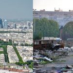
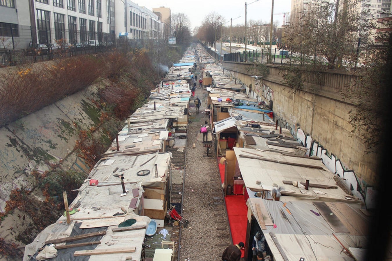
The north-eastern suburban areas of Paris, now known as the Grand Paris region, were subjected to large scale development of housing estates after World War II, with the start of industrialization, and are now seen as stigmatized neighbourhoods with poverty concentration. Among all the departments of the Ile-de-France region (A region of France of which Paris is the capital), Seine-Saint-Denis accounts for the highest share of housing estates with a contribution of about 34.5%. These housing estates were initially mass-produced to address the housing demand with the influx of the working-class immigrant population into the city. This necessitated a huge vacancy of land, which could be spent from the pockets of the suburbs, relocating all the dispersed working-class population living in unfavourable conditions in the city to the suburbs by providing decent conditions of living.
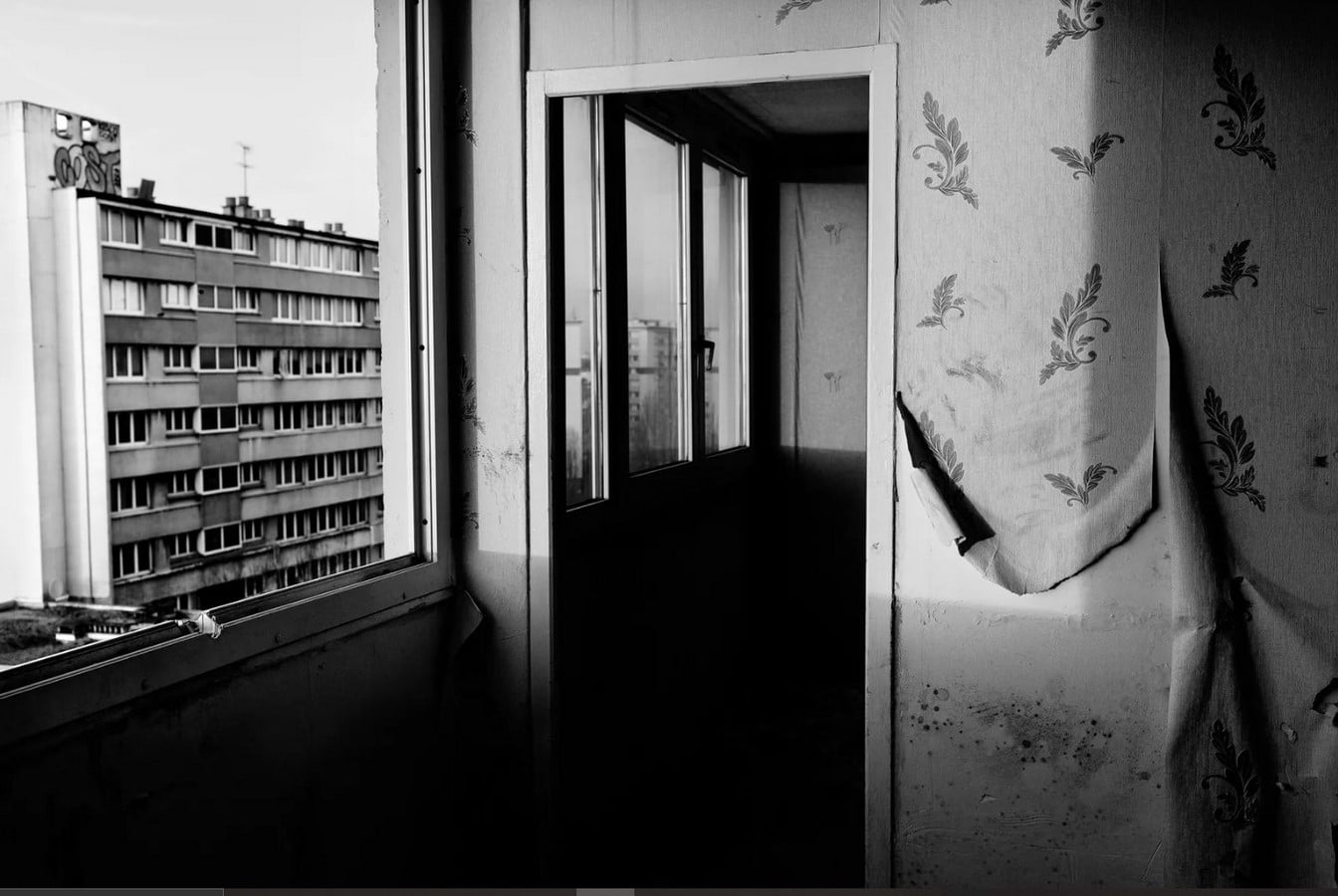
However, after a while, the production of these estates stopped, as they were beginning to be perceived as areas of poverty concentration. Several reasons existed for this new emerging image of the estates; the physical degradation of the buildings due to poor quality material usage, the spatial mono-functionality with no major commercial activities making it a monotonous and an isolated neighbourhood; and many neglected and uncontrolled spaces whose ownership was not clearly defined. Eventually, these areas were labelled as deprived neighbourhoods, which were excluded from the rest of the society. This so formed picture of Saint-Denis prevails even today, with recent immigrants and descendants of working-class immigrants facing issues like discrimination and unemployment. This led to either hunting for alternative sources of income, resulting in petty crime and drug trafficking activities or people leaving behind the social housing when better opportunities approached them. Subsequently, these buildings are occupied by recent migrants or poorer people facing issues such as unemployment.
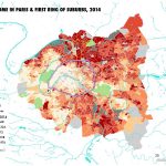
The entire process can be understood as a continuous cycle that repeats itself, hindering the upliftment of the image of these localities and therefore spatially segregating the city between the rich and the poor, producing issues of urban inequalities in Paris. The following image summarizes the level of disparities in the city.
References:
- Benedictus, L., 2017. Blowing in the wind: why do so many cities have poor east ends? [online] the Guardian. Available at: https://www.theguardian.com/cities/2017/may/12/blowing-wind-cities-poor-east-ends.
- Chabrol, M. and Waine, O., 2013. Château Rouge: a “Little Africa” in Paris? [online] Metropolitics.org. Available at: https://metropolitics.org/Chateau-Rouge-a-Little-Africa-in-Paris.html.
- Stanglar, C., 2020. The Death of Working-Class Paris. [online] The Nation. Available at: https://www.thenation.com/article/world/paris-gentrification/.
- Lelévrier C., Melic T. (2018) Impoverishment and Social Fragmentation in Housing Estates of the Paris Region, France. In: Hess D., Tammaru T., van Ham M. (eds) Housing Estates in Europe. The Urban BookSeries. Springer, Cham. https://doi.org/10.1007/978-3-319-92813-5_14