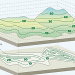
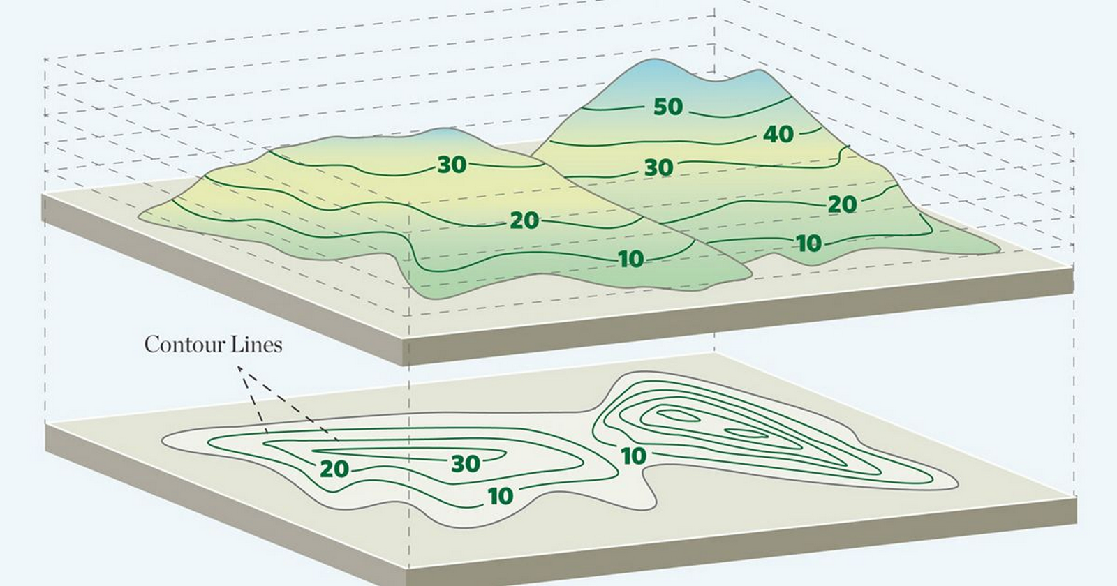
Before a single wall goes up or a roof takes shape, every building begins with a story that is written by its site’s topography. Site topography is far more than a technical survey. Site topography refers to the shape and features of the land’s surface, including elevation, slope, and contour.
Sustainable design is an approach that seeks to minimize negative environmental, social, and economic impacts and to create products, services, or systems with minimal negative impacts. Topography plays an important role in this process, as it influences the orientation of the structure, drainage systems, and microclimate etc.
Defining Site Topography
Topography is basically tells the story of a piece of land, it encompasses of various components like contours and elevation that reveal how the ground rises and falls, slope gradients that indicate the steepness or flatness of areas, natural features such as hills, valleys, rock formations, vegetation, and water bodies, as well as man-made features like retaining walls, graded platforms, or existing structures.
Studying site topography becomes essential for determining not only where to position a building but also how the building can be shaped, oriented, and constructed to achieve long-term sustainable design outcomes that align with human needs as well as provide environmental protection.
The Relationship Between Site Topography and Sustainable Design
The relationship between topography and sustainable design is rooted in the idea that the land itself can guide the creation of a design solution that is responsive and helps with sustainable land management.
The shape, slope, and natural features of a site influence how a building is positioned, and further help to design solutions that capture sunlight, channel wind, and manage water. By creating designs that work with the flow of contours instead of flattening and reducing the cut and fill of them, architects can reduce earthworks, which helps to preserve ecosystems, and eventually maintain natural drainage patterns. Site-sensitive approach not only minimizes environmental impact but also enhances energy efficiency, and ends up creating sustainable design buildings that feel connected to their surroundings.
The original site’s land form offers microclimate benefits, which include influencing sunlight exposure, wind flow, and temperature variations; for example, hills or ridges can shield against harsh winds, reducing dependence on mechanical systems. Additionally, site topography also guides water movement, enabling the integration of contour-based water harvesting.
Architectural strategies that work with topography embrace the land’s form rather than reshaping the land form entirely. Split-level and stepped designs follow the land’s natural gradients, which helps to reduce excavation and create visually engaging designs. Earth-sheltered structures can also be designed to take advantage of the terrain to improve thermal stability and reduce visual impact.
Landscape integration, which can be achieved through terracing, the use of retaining walls, and native planting, not only stabilizes slopes but also creates functional outdoor spaces. Passive climate design makes the most of sun and wind patterns, cutting energy consumption while boosting comfort. These methods deliver lasting sustainable design benefits like reduced environmental impact, greater energy efficiency, as well as enhanced occupant experience through natural light and views, and improved resilience against flooding and erosion.
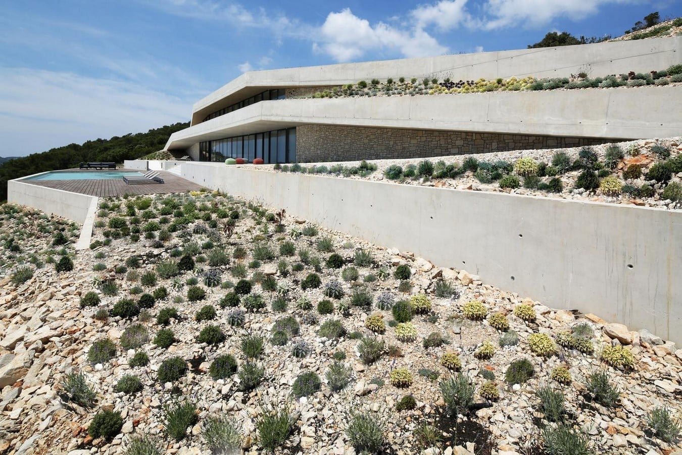
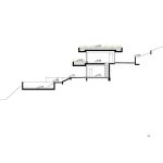
Case Study: Issa Megaron
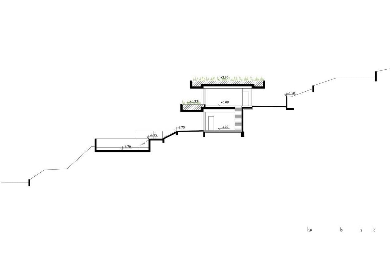
The Issa Megaron, designed by PROARH on Vis Island, Croatia, is nestled into a remote hillside with no existing infrastructure; the house follows the land’s natural contours rather than altering them. This approach minimizes excavation, preserves the surrounding ecosystem, and maintains natural drainage patterns of the site.
Terraces and retaining walls create functional outdoor spaces while stabilizing slopes, and the building’s orientation maximizes natural light and ventilation, reducing reliance on mechanical systems. Green roofs planted with native species reuse excavated soil, improve the insulation of the house, and restore the site’s natural profile.
By respecting the terrain and integrating building form with landscape, the Issa Megaron achieves environmental harmony and energy efficiency, demonstrating how sustainable architectural design can grow from the land itself rather than be imposed upon it.
Understanding site topography is not simply about just reading the contour maps; it is more about reading the character of the land. When architects respond to slope, elevation, vegetation, and water as guiding elements rather than obstacles, the achieved results are buildings that are more sustainable, efficient, and connected to place.
These days, software tools like Geographic Information Systems (GIS), LiDAR scanning, drone surveys, and digital terrain models (DTMs) can be used by architects, urban designers, and urban planners to get a detailed, accurate understanding of a site’s topography. These technologies help to map contours, elevations, slope gradients, and surface features with high precision, often revealing patterns such as subtle drainage lines or wind corridors that aren’t immediately visible by on-site observations. By combining these digital insights received from these software along with on-site observation, designers can design sustainable design solutions with building placement, orientation, and grading as per site topography.
References:
Hellolandmark.com. (2025). What is the site’s topography? | HelloLandMark. [online] Available at: https://hellolandmark.com/what-is-the-sites-topography / [Accessed 10 Aug. 2025].
Ecolife. (2021). Sustainable Design: What Is It Really? [online] Available at: https://www.ecolife.com/dictionary/sustainable-design [Accessed 10 Aug. 2025].
ArchDaily. (2018). Issa Megaron / PROARH. [online] Available at: https://www.archdaily.com/903759/issa-megaron-proarh?ad_source=search&ad_medium=search_result_all [Accessed 10 Aug. 2025].