Every architect has been there—you’re deep into construction documents when the contractor calls. The ceiling heights don’t match the plans. The structural columns aren’t where the survey said they’d be. The existing HVAC ductwork conflicts with your new design. Now you’re facing change orders, schedule delays, and difficult conversations with the client.
These scenarios happen more often than anyone wants to admit, and they’re expensive. The average commercial construction change order costs between $10,000 and $50,000, with MEP coordination issues alone accounting for nearly 40% of all rework costs. But here’s what’s changed: architects no longer have to rely on tape measures, outdated drawings, or assumptions about existing conditions.
LiDAR scanning has evolved from a specialty service to an essential tool for commercial projects—not because it’s high-tech, but because it eliminates the guesswork that leads to those costly phone calls.
What Is LiDAR Scanning in Construction?
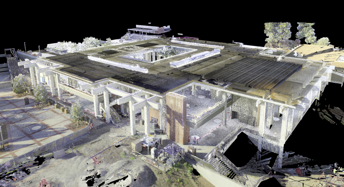
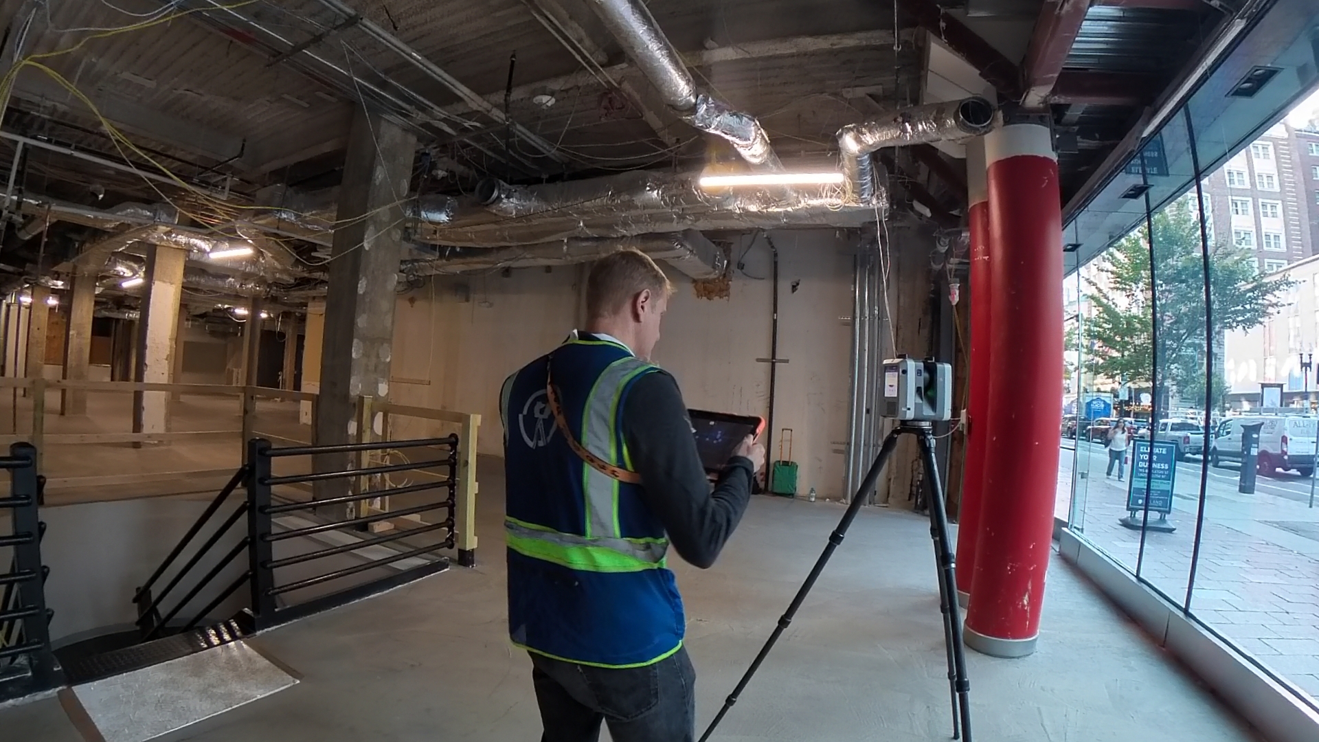 LiDAR (Light Detection and Ranging) uses laser pulses to measure distances with millimeter-level accuracy. A scanner emits millions of laser points per second, capturing every surface, column, pipe, duct, beam, and architectural detail in three-dimensional space. The result is a “point cloud”—a precise digital replica of the existing conditions.
Unlike traditional measuring methods where you capture what you think is important, LiDAR captures everything. You measure the building once, comprehensively, and have a complete record to reference throughout the entire design and construction process. Think of it as creating a digital twin of the space before you ever draw a line.
For commercial architects, this matters because your designs interact with existing conditions in complex ways. That retail tenant improvement isn’t just about the floor plan—it’s about how your new storefront integrates with existing structure, where your MEP systems route around existing utilities, and whether your ceiling design works with actual slab heights, not assumed ones. Learn more about our commercial 3D laser scanning services.
How Accurate Is LiDAR Scanning for Architectural Documentation?
 LiDAR scanning delivers accuracy within ±3mm (about 1/8 inch) across an entire building. To put that in perspective, a tape measure in skilled hands might be accurate to ±1/4 inch over short distances, but that accuracy degrades with distance, fatigue, and the complexity of what you’re measuring.
More importantly, LiDAR doesn’t just measure accurately—it measures comprehensively. When you measure a room with a tape measure, you might capture 20-30 dimensions. A LiDAR scan of that same room captures millions of data points. You’re not deciding what to measure; you’re capturing everything and deciding later what you need.
This comprehensive accuracy prevents the cascade of small errors that plague commercial renovation projects. When your structural drawings show columns within 1/8 inch of their actual location, your MEP engineers can design with confidence. When your ceiling heights are verified across the entire floor plate, your lighting design works the first time. When your contractor can see the actual conditions in 3D before ordering materials, they order the right materials.
What Are the Real Benefits of LiDAR Scanning for Architects?
Beyond accuracy, LiDAR scanning transforms how architects work on commercial projects in three significant ways:
Reduced Site Visits: Instead of multiple measuring trips, you scan once. Need to verify something during design? Pull up the point cloud. Contractor has a question during construction? Share the scan file. One comprehensive site visit replaces 3-5 measurement trips.
Fewer RFIs and Change Orders: When contractors can see actual conditions in the point cloud before they bid, they bid accurately. When your MEP engineers can design around existing utilities they can actually see, they don’t discover conflicts in the field. Projects using LiDAR documentation typically see 30-40% fewer RFIs and change orders related to existing conditions.
Better Client Communication: Show your client the existing building in 3D, then overlay your design. They understand the project immediately. No more “I thought the ceiling was higher” conversations after construction starts. The point cloud becomes a common reference point for everyone—owner, architect, engineers, contractor.
How Much Does LiDAR Scanning Cost for Commercial Projects?
A typical commercial LiDAR scan ranges from $3,000 to $8,000 depending on the building size and complexity. A 10,000 SF retail space might cost $3,500. A 20,000 SF office building might cost $6,000. A complex historic structure with multiple floors and intricate details might reach $10,000.
Here’s the math that matters: if LiDAR scanning prevents just one change order (average cost: $15,000-$30,000), it pays for itself several times over. Most commercial projects using LiDAR documentation avoid 3-5 change orders related to existing conditions, saving $45,000-$150,000 or more.
The real question isn’t “can we afford LiDAR scanning?” It’s “can we afford not to have accurate documentation when we’re designing a $2 million renovation?” Get a project quote for your commercial building.
When Should Architects Use LiDAR Instead of Traditional Measuring?
 LiDAR scanning makes sense for most commercial projects, but it’s especially valuable in specific situations:
Complex Existing Conditions: Multi-story buildings, exposed structure, visible MEP systems, irregular spaces. Basically, anywhere you’d spend hours with a tape measure and still miss important details.
Historic Buildings: Where you need to document ornate details, verify structural elements, and create records without physical contact. LiDAR captures intricate moldings, cornices, and architectural features that are nearly impossible to measure traditionally. See our historic preservation scanning projects.
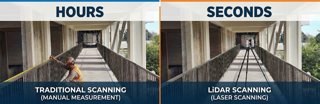
Tight Schedules: When you need comprehensive documentation quickly. A 20,000 SF building might take days to measure traditionally but only 4-6 hours to scan.
High Coordination Requirements: Tenant improvements, MEP-intensive projects, spaces where multiple trades need to coordinate in tight ceiling plenums.
Occupied Buildings: Hotels, retail stores, restaurants—spaces where you can’t disrupt operations for multiple measuring visits. Scan during off-hours once, design anytime. Our hospitality scanning services are specifically designed for operational properties.
Traditional measuring still works for simple spaces—an empty shell with regular dimensions, new construction where you’re verifying builder’s work, small projects where the measuring cost approaches the scanning cost. But for most commercial architecture projects, LiDAR has become the standard, not the exception.
How Long Does a Commercial LiDAR Scan Actually Take?
The scanning itself is faster than most architects expect. A typical commercial project breaks down like this:
- Small retail space (5,000 SF): 2-3 hours on-site
- Medium office floor (20,000 SF): 4-6 hours on-site
- Large commercial building (50,000+ SF): 1-2 days on-site
- Multi-building campus: 3-5 days depending on complexity
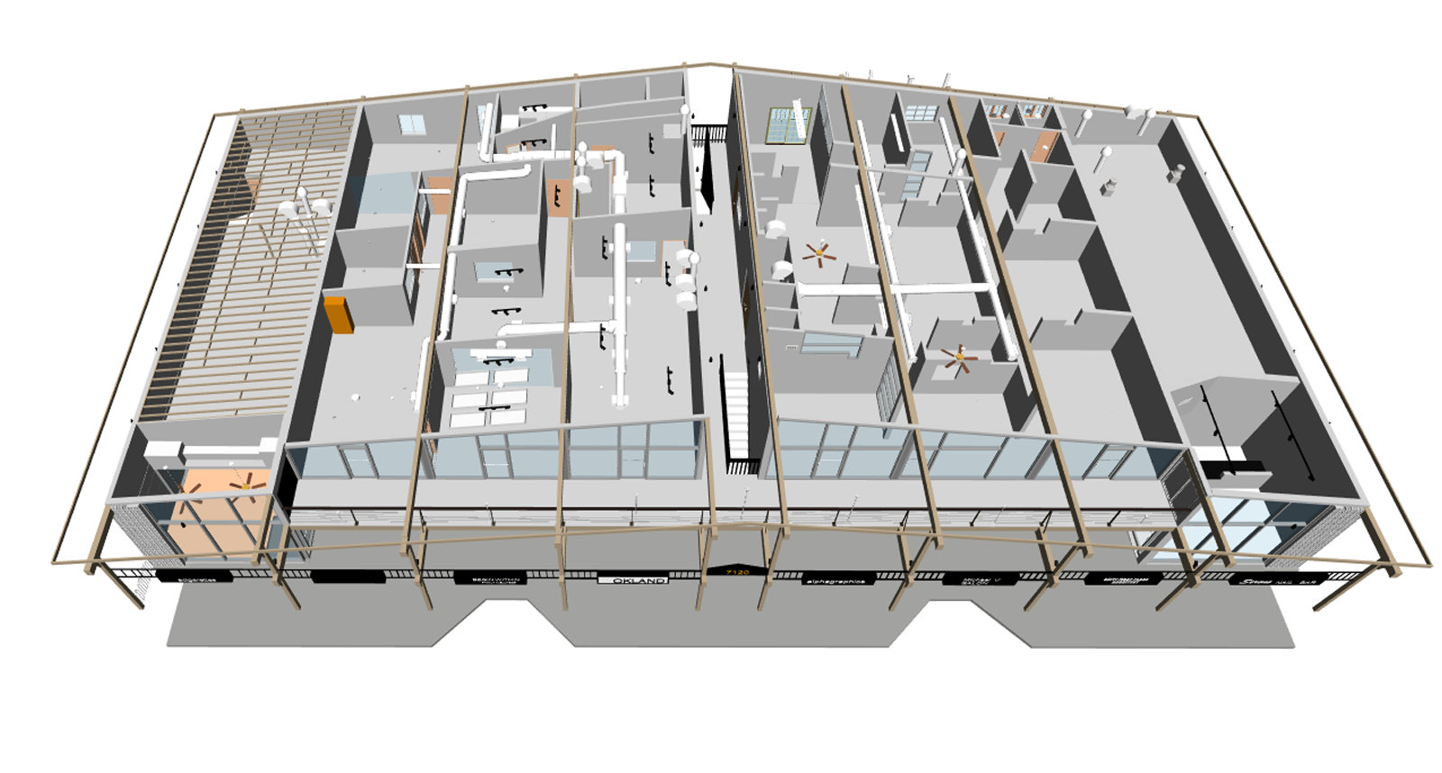
After scanning, processing and deliverable creation takes 3-7 business days. You’ll receive the point cloud, 2D floor plans, elevations, sections, and often a Revit model—whatever documentation format your project needs.
Compare that to traditional measuring: multiple site visits, days of manual drafting, frequent return trips to verify dimensions, and you’re still not certain you captured everything. With LiDAR, you measure once comprehensively and have confidence in your documentation throughout the project.
What Can LiDAR Detect That Traditional Methods Miss?
 This is where LiDAR scanning becomes genuinely transformative. Traditional measuring captures what you decide to measure. LiDAR captures everything, including things you didn’t know to look for:
Above-Ceiling Conditions: Existing ductwork, pipes, conduit, structure, and available plenum space. Your MEP engineers can see exactly what they’re working around before they design a single duct run.
Out-of-Plumb Walls: That wall isn’t quite vertical? LiDAR captures it. The existing drawings show the wall straight, but it actually leans 2 inches over 12 feet? You’ll know before your millwork shop builds custom casework that doesn’t fit.
Floor Flatness Issues: Critical for retail fixtures, display walls, and partition systems. LiDAR documents actual floor conditions, not assumed ones.
Structural Deflection: Beams sag over time. Floors settle. Roofs deflect. LiDAR captures the building as it actually exists, not as it was originally built.
Hidden Details: Cornices, coffers, mechanical registers, sprinkler heads, light fixtures—everything visible gets captured, even details you weren’t specifically measuring for.
One architect described it perfectly: “With traditional measuring, I captured what I thought I needed. With LiDAR, I discovered what I actually needed to know.”
How Does LiDAR Improve MEP Coordination in Renovation Projects?
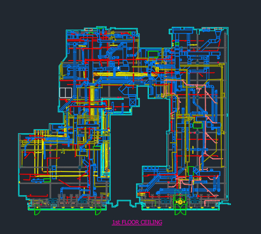 MEP coordination failures cause more project delays and cost overruns than almost any other issue in commercial renovation. The problem is simple: MEP engineers design based on assumed ceiling heights, assumed structural locations, and drawings that may not reflect years of renovations and modifications.
LiDAR scanning solves this by giving MEP engineers the truth. They can see the actual structure, the existing ductwork that needs to remain, the electrical conduit that can’t move, the plumbing that constrains their routing. They design around reality, not assumptions.
The result: fewer conflicts discovered during construction, more accurate contractor bids, faster installation, and significantly fewer change orders. Projects using LiDAR for MEP coordination typically report 40-60% fewer MEP-related RFIs and change orders.
For architects, this means fewer middle-of-construction coordination meetings, fewer emergency redesigns, and projects that actually finish on schedule.
Can You Use LiDAR to Document Buildings That Are Currently Occupied?
Absolutely—and this is one of LiDAR’s biggest advantages for commercial work. Hotels don’t close for your measurements. Retail stores don’t shut down for documentation. Offices don’t evacuate so you can measure.
LiDAR scanning happens quickly and non-disruptively. Scanners set up in minutes, capture comprehensive data, and move to the next location. Retail stores scan during off-hours. Hotels scan floor-by-floor. Offices scan during evenings or weekends.
The technology doesn’t require touching surfaces, moving furniture, or disrupting operations. You’re documenting the space as it exists, occupied and operational.
This is particularly valuable for the projects you’re working on—national retail rollouts, hotel renovations, restaurant refreshes—where business continuity isn’t just preferred, it’s required.
The Bottom Line for Architects
LiDAR scanning has moved from specialty service to essential tool because it solves the fundamental problem that plagues commercial renovation projects: we’re designing based on assumptions instead of reality.
Every project using accurate LiDAR documentation reports the same results—fewer surprises, fewer change orders, better coordination, and projects that actually match the design intent. The cost is modest, the time investment is minimal, and the risk reduction is substantial.
The question isn’t whether to use LiDAR scanning anymore. It’s why you’d design a commercial project without it.
Looking for LiDAR scanning services for your next commercial project? LiDAR Precise Plans provides precision as-built documentation across Las Vegas, Phoenix, Los Angeles, San Francisco, Denver, Salt Lake City, and Austin. Contact us to discuss your project needs.