Origins and the Uruk Period
Established in 4000 BCE Uruk was the longest continuously inhabited city in the world, its history spanning 5500 years. Situated 300km south of Baghdad and 15 km east of Samava, Uruk-modern day Warqa lies in the southern Mesopotamian plains called the alluvium- a region with historically unpredictable rainfall patterns resulting in the need for ingenuity in irrigation practices. Mario Liverani notes in the book Uruk: The first city how the choice of agriculture techniques led to an urban revolution; systems like Furrow irrigation required a central administration to be maintained while also incentivizing the use of tools and animal traction.
Increased agricultural productivity created a surplus of food and labour, freeing people from the burden of subsistence farming; a new administrative class emerged called the Palace of the Temple. They reinvested the surplus back into the society after the two Ubaid settlements merged to form the city of Uruk.
The Uruk Period from 4100 to 2900 BCE is divided into 8 phases with Uruk becoming the region’s largest urban centre and trading hub by 3200 BCE in the Middle Uruk Period. The city had a population of 40,000 inhabitants and came to cover an area of 5.5 kilometre square with its mighty fortifications extending up to 9km.
According to the chronology of Summerian kings, the legendary Gilgamesh ruled the city of Uruk in the 27th century BCE with the first recorded poem in history, the epic of Gilgamesh recounting the fables of this legendary king. Describes the establishment of trade links to the surrounding region that brought in primarily two kinds of trading goods, the unprocessed like timber and the prestige goods like rare metals and gems. To administer these extensive trading networks the use of writing emerged for record keeping and counting.
Architectural Layout of the City
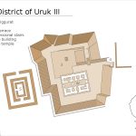
An extensive canal system ran through the Uruk from north to south. These large canals were used for transport, confirmed by the presence of harbours, Watergates, and landing places. The city had two major districts; the Eanna district honoured the Inana, more commonly known in Sumeric tradition as Ishtar, Goddess of fertility, love, and war. The second district was Anu which honoured Anu the God of heaven who was also believed by some to be the father of Inana.

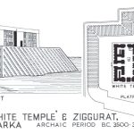
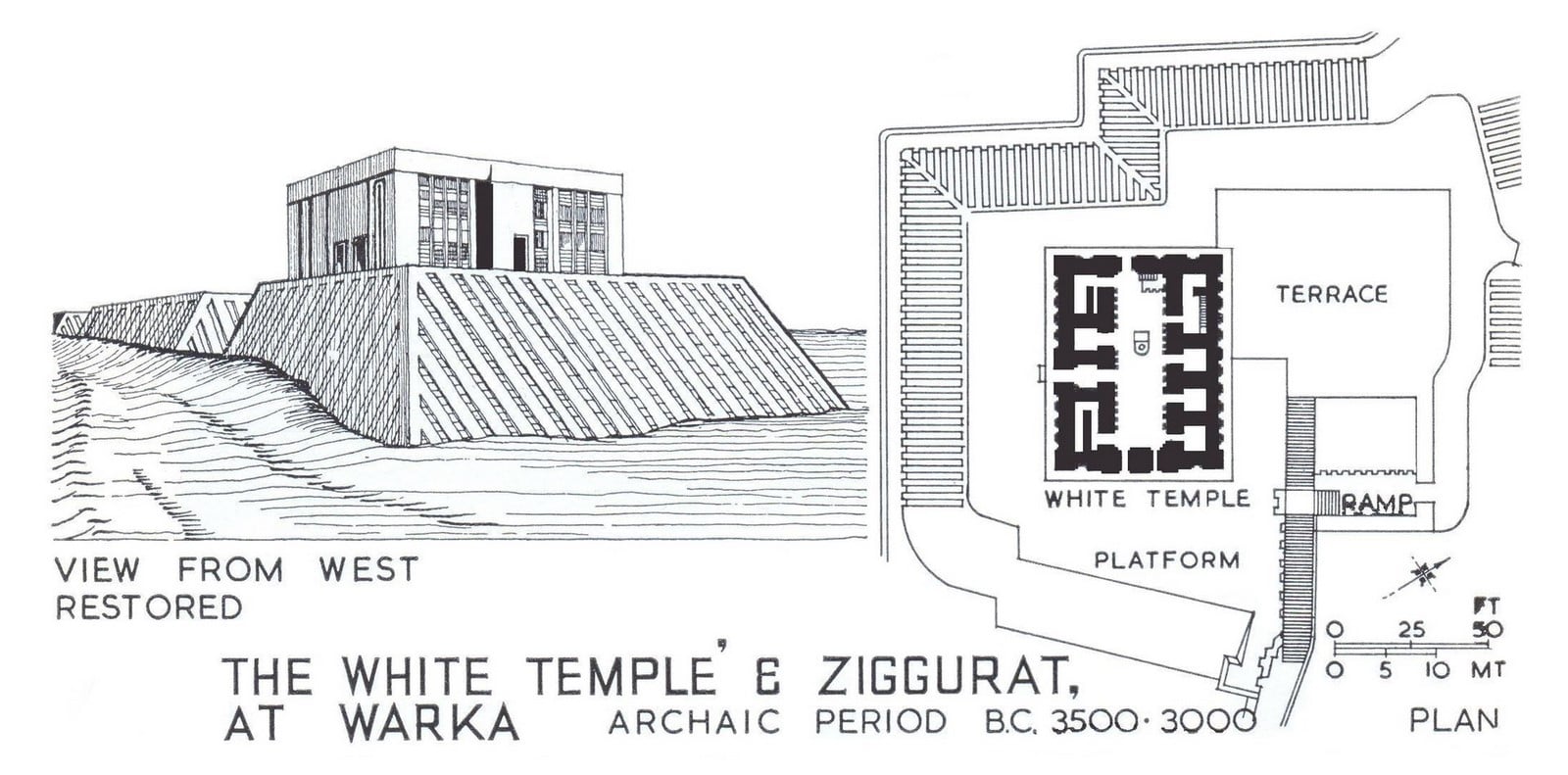
The older of the two districts is Anu which consists of a single massive terrace, the Anu Ziggurat. It started as a mound topped by a cella, expanding during the 14 phases of construction. The structure was built over a rammed earth foundation using limestone and bitumen and had a limestone staircase used for processions.
The White temple it’s distinctive gypsum plaster was added over the Anu ziggurat, elevating it to 21 meters to reflect the might of Uruk.
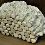
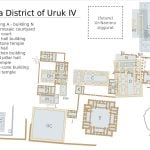
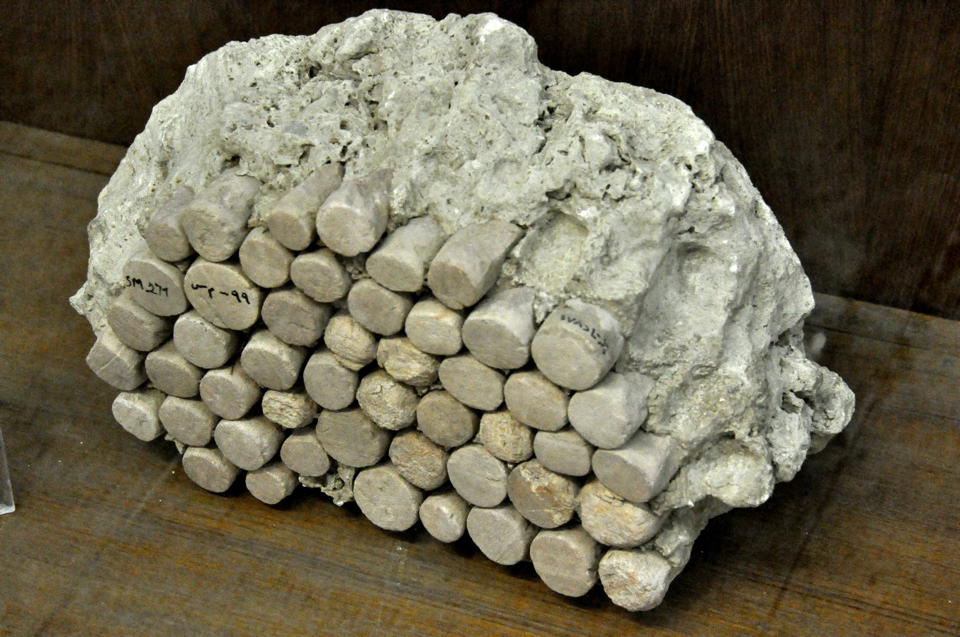
The Eanna district was arranged around goddess Inana’s ziggurat as a series of courtyards ho several small rooms that served ceremonial purposes but could also be used as shops, schools, or offices. The first building in the district was a Stone-Cone Temple enclosed by a limestone wall and an elaborate system of buttresses. The limestone and stone cone temples in Eanna featured the stone mosaic technique which inlaid stone cones on a gypsum background.
These two temples were a prototype of the Mesopotamian Architectural typology Tripartite with three parallel halls and T-Shaped with a central hall extending into two perpendicular bays at one end. The Uruk IV period saw the district expand to 600 hectares with many new and impressive structures; the great court with a sunken courtyard and an aqueduct to irrigate its gardens.

In 200 BC, the ‘Great Sanctuary’ of Ishtar was added between the Anu and Eanna districts. The ziggurat of the temple of Anu was rebuilt in this period and was the largest ever built in Mesopotamia. However, social upheavals plagued the region with an impact on the architecture of the Eanna district; which became more fortress-like.
In the second half of the 18th century, 300 years of drought led to the region depopulating as residents moved to the city of Kish. After a second dry period, Uruk repopulated, becoming the chief mediator between Babylonian kings and the city-states of the south.
Decline
The Euphrates had been shifting west; the irrigation canals eventually ran dry by the 4th century AD. Another theory was the shift of economic trade routes of the Sasanian empire going further inland after the Seleucids lost Mesopotamia to the Parthians in 141 BC. As a result, Uruk was completely abandoned by the 2nd century AD. Much of the Summer became pasture grounds for pneumatic shepherds and the ruins of Uruk remained untouched.
Exploration and Present day state
William Loftus and later the German Oriental Society carried out archaeological expeditions of Uruk. Exploration resumed post World War 1 concluded in the 1970s. More recently 2001-2019, a map of the city’s buried foundation was created using a magnetometer prepared by a team from Munich University. It showed some fascinating findings; how the centre of Uruk stands on 35 layers of the building running 25 meters deep, the oldest layer dating back to 4500 BC. Much remains unexplored within these ancient ruins of the world’s first city; we are only at the brink of exploring its many layers of history.
Citations:
Baker, H.D.(2003) “The Urban Landscape in First Millennium BC Babylonia”
Charvát, Petr; Zainab Bahrani; Marc Van de Mieroop (2002).Mesopotamia before history
Crawford, Harriet E. W. (2004). Sumer and Summerians
Fassbinder, J.W.E., and H. Becker. (2003) Magnetometry at Uruk (Iraq): The city of King Gilgamesh
Harmansah, Ömür (2007). “The Archaeology of Mesopotamia: Ceremonial centers, urbanization and state formation in Southern Mesopotamia”.
Nissen, Hans J (2003). “Uruk and the formation of the city”. In Aruz, J (ed.). Art of the First Cities: The Third Millennium B.C. from the Mediterranean to the Indus. New York: Metropolitan Museum of Art.
Oppenheim, A. Leo; Erica Reiner (1977). Ancient Mesopotamia: Portrait of a Dead Civilization.